
How an aerial photo shows that patience pays off
Our work at eMission-X is often unspectacular—at least at first glance.
We buy land. We stop its commercial use. Sometimes we help by carrying out targeted initial restoration efforts.
And then?
Then we let nature take its course.
We give it space and, above all, time. Because rewilding doesn’t mean constantly shaping or controlling nature. It means creating conditions under which it can develop on its own again.
But that’s precisely where the challenge lies: How do you make work visible when deliberate non-intervention plays a central role?
A Green Island in Wusseken

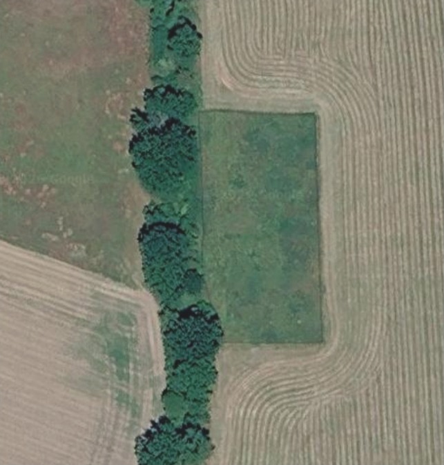
We made an exciting discovery while looking at a recent aerial photo of our site in Wusseken (Mecklenburg-Western Pomerania).
In the middle of a predominantly agricultural landscape, our rewilding site is clearly visible—like a small green island amidst cultivated fields.
On the left side of the image is an existing wooded area. To the right of it lies our property, whose boundaries are marked in green on the aerial photo.
We have completely ceased commercial use of the entire 8,250 m² area. Additionally, initial renaturation has been carried out on approximately 3,800 m².
The area is now allowed to develop largely on its own.

Image source: Google Maps, aerial photo © 2026 Airbus, GeoBasis-DE/BKG, Maxar Technologies; map data © 2026 GeoBasis-DE/BKG.
Rewilding takes time
Initial restoration is not a finished ecosystem. It is a first step.
What emerges from this is determined in the long term by natural processes: plants spread, trees and shrubs develop, habitats change, and new species may arrive.
Some changes become visible after just a few years. Others take decades.
We don’t know exactly today what our site in Wusseken will look like in 10, 20, or 50 years. And that’s exactly what makes rewilding so exciting.
We don’t impose a predefined landscape on nature. We give it the opportunity to shape its own future.
From 8,250 square meters on paper to visible wilderness
Until now, our 8,250 m² in Wusseken was primarily just a number: a parcel in the land registry, an area on a map, a small dot in our digital property overview.
Now, for the first time, we can see it from the air as a distinct area within its surroundings.
This is a special moment for us.
However, a single aerial photograph does not yet show how successfully an ecosystem is developing. That requires further observations, comparative images, and long-term data.
What will Wusseken look like in 50 years?
That is precisely the question we want to explore.
We want to document the long-term development of our natural areas—using photographs, aerial images, vegetation observations, and, where appropriate, scientific monitoring.
What changes after five years? Which plant species become dominant? Which animals find new habitats? How do woodlands and other natural structures develop?
We want not only to observe these developments ourselves but also to make them understandable to others.
Because nature takes time. And people sometimes need images to see what patience can achieve.
Wusseken is just the beginning.
More wild. Bit by bit.